Jul 192014
 

To sum up:

  • MH17 was shot down over a region of Ukraine controlled by pro-Russian separatists.
  • Said separatists have shot down several Ukrainian military aircraft in recent weeks, including an AN-26 transport aircraft.
  • Said separatists recently bragged about having acquired a powerful truck-mounted anti-aircraft missile battery.
  • Said separatists posted publicly on social media, complete with eyewitness video, about having shot down another AN-26 at the time when MH17 crashed, and in the same region.
  • The posts came from a source that was accepted as credible in the past, and were widely circulated in Russian media.
  • The posts were removed a few hours after it became clear that the aircraft in question was in fact a civilian airliner.
  • The Ukrainian government published intercepted cellular telephone calls, in which alleged separatist leaders, and possibly their Russian contacts, were discussing the incident. Although the source (Ukraine) is not impartial, no reason was presented so far to question the authenticity of the intercepts.

In light of all these facts, even if the black boxes can never be analyzed, even if the wreckage has been disturbed, even if the site has been looted, even if no investigators are allowed on the scene, I think that the basic conclusion is rock solid: MH17 was shot down by pro-Russian separatists who mistook it for a Ukrainian military airplane, and who were possibly not aware of the fact that international air traffic was allowed to fly over the disputed region at altitudes greater than 32,000 feet.

The only real questions that remain, in my opinion, concern the extent of Russia’s involvement. Where did the missile come from? Was it captured by the separatists themselves or was it provided by Russia? Who operated the missile? Was it Ukrainian rebels who may have received relevant training while serving in the military, or was it personnel provided by Russia?

From The Times of London.

The answers to these questions determine the degree of Mr. Putin’s culpability.

The Ukrainians also presented a video, showing the alleged missile truck, with one of four missiles missing, en route to Russia. There were also reports according to which the airplanes black boxes were found and have since been removed to Russia. If true, these facts only increase the culpability of Mr. Putin’s government.

Meanwhile, Russia’s propaganda machine is now in high gear, full of insinuations, including these:

  • Ukrainian air defense forces were tracking MH17. (Of course they were. That’s what air defense forces are supposed to do. I know… I served in one of them 33 years ago as an unhappy conscript, trained as a radar operator.)
  • Ukraine is responsible for a crime that happened over her territory. (Except when said territory is controlled by separatists who are supported, overtly and covertly, by a foreign government.)
  • MH17 earlier flew near Mr. Putin’s presidential airplane, which had similar markings, and NATO may have been trying to murder the Russian president. (Mr. Putin’s airplane never entered Ukrainian airspace. NATO does not usually miss its target by several hundred miles. And the actual locations of civilian aircraft in European airspace are available to anyone with a Web browser, which includes NATO officers but not necessarily ragtag paramilitaries in the fields of eastern Ukraine.)

So there. Tensions are never a good thing, especially with a nuclear superpower like Russia, but I nonetheless believe that at the very least, Mr. Putin should be held accountable for being an accomplice in a crime against humanity.

 Posted by at 4:45 pm
Jul 172014
 

Here is the Google Maps location of the last ADS-B coordinate transmitted by MH17:

And here is a (since deleted) social media release by Igor Ivanovich Strelkov, commander of the separatist Donbass People’s militia:

The underlined text reads, in English (slightly edited Google translation):

In the area Torrez just downed plane An-26, lying somewhere in the mine “Progress.” As we warned – do not fly in “our sky.” And here is the video confirmation of the “birdfall.”

Bravo, murderers. I hope you are proud. And congratulations are also due to Mr. Putin; after all, if you give a lit match to a child, you cannot really disclaim responsibility when the house burns down.

 Posted by at 3:10 pm
Jul 172014
 

Malaysian airlines confirms that it lost contact with MH17, a scheduled flight from Amsterdam to Kuala Lumpur.

According to Interfax, the flight went down near the Ukrainian-Russian border. As this is a known conflict zone, it raises the possibility of foul play, especially considering that a few days ago, Ukraine lost a cargo plane and it may have been shot down by Russia.

On the other hand, whatever the cause, it cannot be good news for Boeing either.

 Posted by at 11:50 am
Jun 032014
 

So a few days ago, Inmarsat and the Malaysian government released what they call the “raw” data about the so-called handshakes between Inmarsat’s Indian Ocean satellite and the ill-fated airliner.

I looked at the data. It was presented in a most inconvenient form, a PDF file with little explanation and with copy-and-paste disabled. Nonetheless, I was able to copy the data to a spreadsheet with only a moderate effort, using Firefox’s built-in PDF viewer instead of Acrobat.

The data set is very detailed, but really, only two columns seem to be of interest: the so-called “beat frequency offset” (BFO) and “burst timing offset” (BTO).

To make a long story short: I am able to confirm the approximate location of the southern search area that was initially explored on March 18 or thereabouts. I am not able to find any rationale for preferring the southerly route over the northern route. The data are symmetrical in this regard. If the airplane flew north, it would have ended up somewhere in Kazakhstan, again in agreement with published predictions for the northerly route.

So here is what I did to arrive at these conclusions.

The little explanation that is offered suggests to me that the BFO is essentially a one-way Doppler frequency shift \((\Delta f)\); whereas the BTO is a two-way propagation delay \((\Delta t)\), with some constant, unknown bias.

The raw data are pretty confusing:

First, there is a lot of stuff happening before and around take-off, around 16:41 UTC. Then something clearly changes around 17:07, the time of the last reported ACARS contact; and once again, there is an anomaly around 18:15, the time of the last reported primary radar contact.

So rightly or wrongly I am summarily dismissing these early data points, as I cannot make heads or tails of them.

Similarly, I am dismissing the very last data points, when clearly some other anomaly was taking place.

Which leaves me with a total of 5 “clean” pairs (both BTO and BFO) of data points between 19:41 and 00:11 UTC. There are two additional data points around 18:15: one is BFO only, the other is BTO only as the corresponding BFO is ambiguous.

My basic assumptions are as follows:

I accept the published time and location of the last civilian (secondary) radar contact (6°55’15” N, 103°34’43” E at 17:21 UTC) and the last military (primary) radar contact (6°49’38” N, 97°43’15” E at 18:15 UTC) as valid. I am assuming that the aircraft flew between these points in a straight line (i.e., along a great circle) at constant speed.

I accept the validity of the aforementioned “clean” Inmarsat data points, 7 in total (2 partial). I am assuming that during this phase of the flight, the aircraft was again traveling in a straight line (that is, along another great circle) at constant speed.

For the sake of simplicity, I assume that the satellite is above the equator, exactly stationary relative to the Earth’s surface, and that the aircraft is not affected by wind. (A more refined calculation might take into account the slight motion of the Inmarsat IOR satellite relative to the ground, and also the known wind patterns at the time of the aircraft’s disappearance. Of course such an analysis is necessarily fraught with significant uncertainties, as not knowing the altitude of the aircraft means we don’t know how it is affected by wind. So the resulting error may not be much smaller than the error I introduced into my calculations by these simplifications.)

The first order of the day was to find a formulation that characterizes the airplane’s trajectory using a minimal number of parameters. For this, I drew the following diagram:

mh370-position

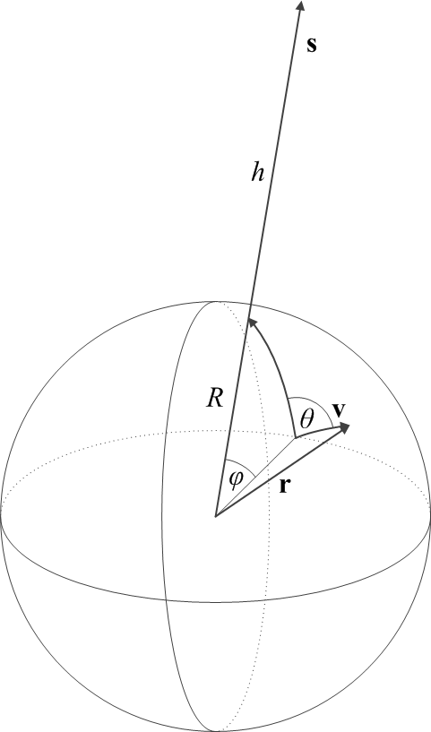
Here, \(R\simeq 6,371~{\rm km}\) is the Earth’s radius; \({\bf s}\) is the geocentric position vector (of length \(R+h\)) of the Inmarsat satellite, which is hovering at an altitude of \(h\simeq 35,800~{\rm km}\); and \(\phi\) is the geocentric angle between the position of the satellite and the initial position of the airplane, which is moving with velocity \({\bf v}\). The angle between the initial velocity vector of the airplane and the direction of the satellite ground track position is given by \(\theta\).

In a Cartesian coordinate system in which the initial position, \({\bf r}(t=t_0)\) of the airplane is given by \({\bf r}_0=[0, 0, R]\) and \({\bf s}\) is in the \(y-z\) plane, these vectors are given by

\begin{align}
{\bf s}&=[0,(R+h)\sin\phi,(R+h)\cos\phi],\\
{\bf r}&=[R\sin\theta\sin\omega t,R\cos\theta\sin\omega t,R\cos\omega t],\\
{\bf v}&=\dot{\bf r}=[v\sin\theta\cos\omega t,v\cos\theta\cos\omega t,-v\sin\omega t],
\end{align}

where the angular velocity is given by \(\omega=v/R\) and of course \(v=|{\bf v}|\).

The distance between the satellite and the airplane is then given by \(d=|{\bf s}-{\bf r}|\). The line-of-sight velocity of the airplane, as seen from the satellite, is given by \(v_{\rm LOS}=({\bf s}-{\bf r})\cdot{\bf v}/d\). This leads us directly to a model of the two Inmarsat observables:

\begin{align}
|\Delta t|&=\left|\frac{2d}{c}\right|,\\
|\Delta f|&=\left|\frac{v_{\rm LOS}}{c}f_0\right|,
\end{align}

where \(c\) is the velocity of light and \(f_0\simeq 1.6435~{\rm GHz}\) is the transmitter frequency on board the aircraft. Absolute values are used to account for the inherent sign ambiguity in the reported observables.

This is not quite the end of the story, however. We know from the description of the Inmarsat data that \(\Delta t\) includes an unknown constant bias \(\Delta t_0\). Furthermore, \(\Delta f\) not only includes an unknown constant bias \(\Delta f_0\) but also includes partial compensation for the Doppler effect by the aircraft transmitter, which we can represent by a scaling factor \(\xi\). Thus the model for the observables must be revised as follows:

\begin{align}
|\Delta t-\Delta t_0|&=\left|\frac{2d}{c}\right|,\\
|\Delta f-\Delta f_0|&=\xi\left|\frac{v_{\rm LOS}}{c}f_0\right|,
\end{align}

This, then, represents our final model for the Inmarsat observables. The model has several adjustable parameters, namely \(v\), \(\phi\), \(\theta\), \(\Delta t_0\), \(\Delta f_0\) and \(\xi\), which can be used to fit the scarce BFO and BTO data points. One question remains, however: shall these be fitted together or separately? Fitting them together would require weighting data of different physical dimenions (seconds for BTO, inverse seconds, or Hz, for BFO). These weights would normally come from estimates of standard deviation on the data, but we have no such estimates. The unknown weights can completely alter the resulting parameter fits, and produce nonsensical results.

Instead, I opted to fit the BFO and BTO data points separately. First, I fitted BTO against \(\Delta t\) by varying only \(v\), \(\phi\), \(\theta\) and \(\Delta t_0\), as the remaining two parameters have no effect on \(\Delta t\). This yielded an estimate for the trajectory of the aircraft. Next, I checked if I can fit \(\Delta f\) against BFO by varying only \(\Delta f_0\) and \(\xi\). (NB: So I am really not fitting the trajectory to the Doppler frequency shift, I am merely checking the validity of the fit. If the model I use is not appropriate to estimate the transmitter frequency bias and Doppler compensation, it might explain why Inmarsat are confident that the northerly route can be excluded.)

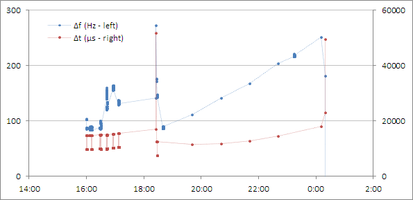
Without further ado, the following plot demonstrates the result:

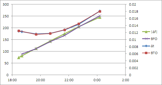
In this plot, the vertical axis on the left is in Hz (for \(|\Delta f|\) and BFO) whereas the vertical axis on the right is in seconds (for \(\Delta t\) and BTO). Yes, I used Microsoft Excel… when you have a nail, a hammer will do nicely.

The values that I obtained for this fit are given by:

\begin{align}
v&=867.16~{\rm kph},\\
\phi&=32.12^\circ,\\
\theta&=-86.55^\circ,\\
\Delta t_0&=0.234572~{\rm s},\\
\Delta f_0&=121.7882~{\rm Hz},\\
\xi&=-0.18199.
\end{align}

This fit by itself does not tell me where the aircraft flew. That is because the model is rotationally symmetric around the ground track position of the Inmarsat satellite. What it does tell me is that at \(t=t_0\) (I arbitrarily chose \(t_0\) to be 19:41 UTC, the time of the first clean Inmarsat data point with both BFO and BTO) the aircraft was on a circle from which the satellite could be seen at 52.6° above the horizon; whereas at the time of the last data point, at 0:11 UTC, the satellite-to-horizon angle was 38.6°.

This is encouraging, as it agrees with published estimates of the infamous “Inmarsat arcs” that position the aircraft along an arc from which the satellite viewing angle is approximately 40°.

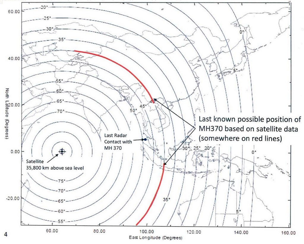
But I can do better than this. Let me take a closer look at the two radar data points at 17:21 and 18:15 UTC. These correspond to a great circle trajectory with a velocity of 718.6 kph, almost exactly in the direction of the Inmarsat satellite. By simultaneously extrapolating this trajectory forward and the just calculated Inmarsat-based trajectory backward (for details, see the Wikipedia article on great circle navigation), I can find the time \(t\) when the two trajectories have matching satellite viewing angles. This happens just a few seconds after the last military radar contact at 18:15.

This means that I have an actual starting position for the Inmarsat track at 6°49’34” N, 97°40’47” E, at 18:15:22.7 UTC. If my calculations are valid, at this spot the aircraft would have turned to follow a trajectory that is nearly at a right angle to the line that connects its position to the satellite ground track position.

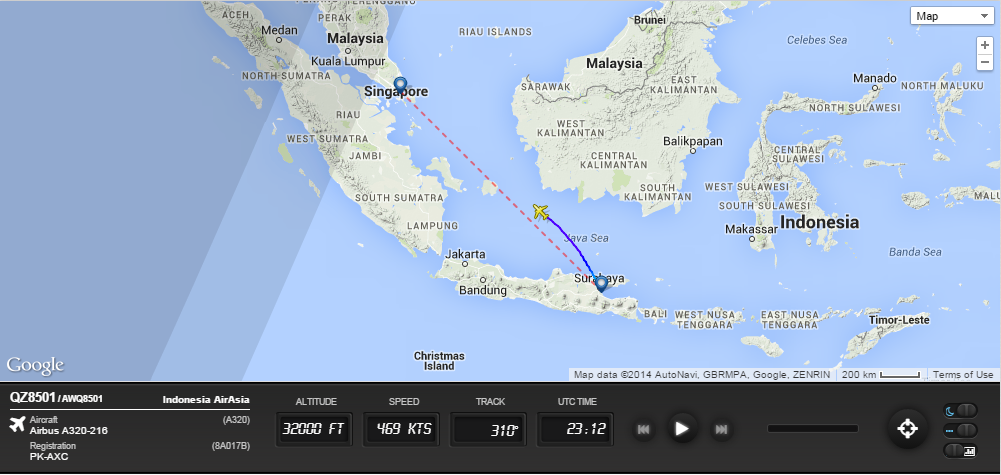
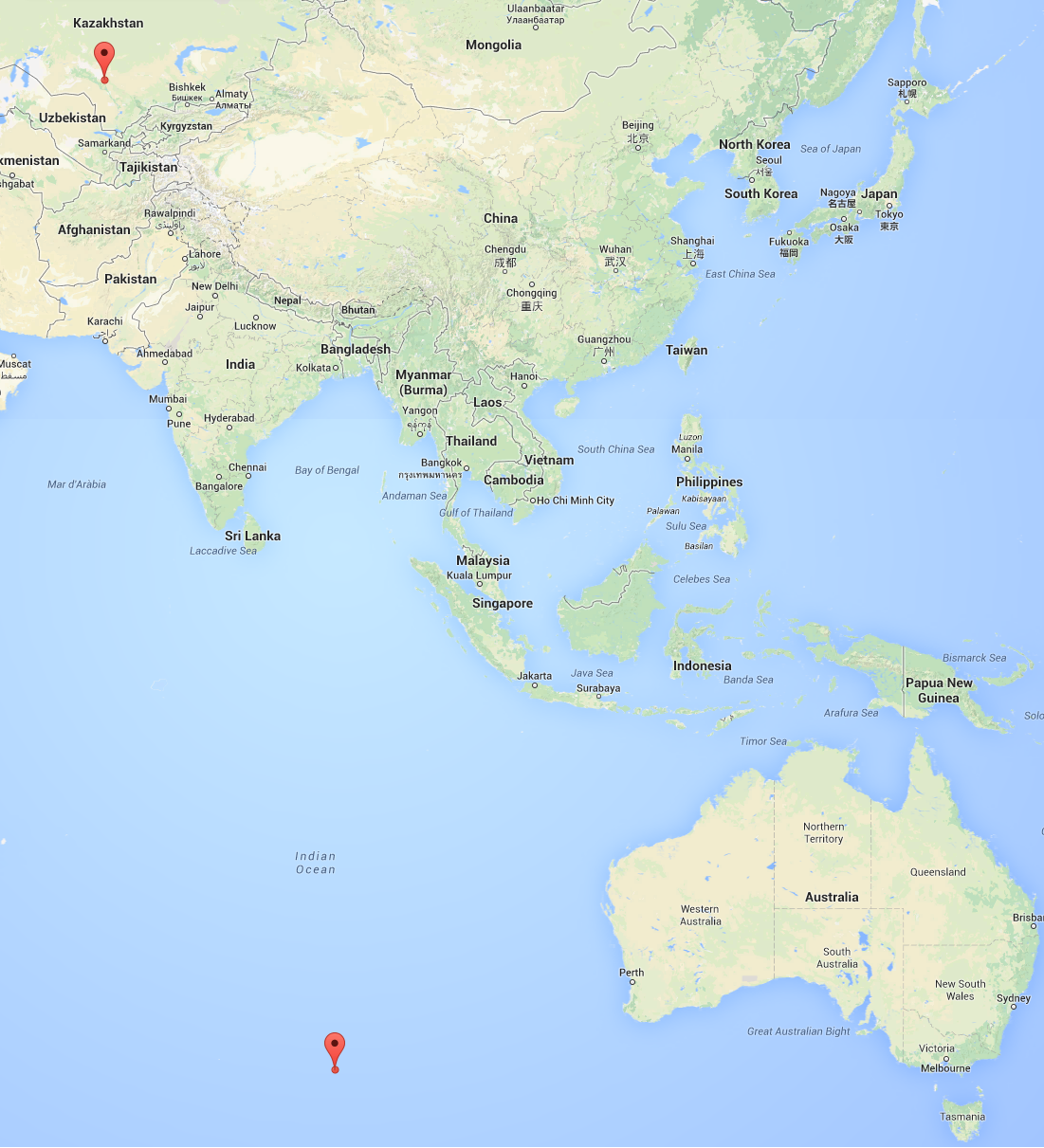
One question, however, remains and it is a nagging one. Did the aircraft turn north or south? Malaysian authorities and Inmarsat insist on the southern track. But I see nothing in the data that they released to support this assertion. If the aircraft turned south, it would have ended up at 38°36’30″S, 88°17’27″E by my calculation, a position that is pretty close to the original search location southwest of Perth, Australia in the Southern Indian Ocean. Therefore, I can confirm the validity of this part of Inmarsat’s analysis.

But what if the airplane flew north instead? That would put it at 44°34’1″N, 66°55’42″E, somewhere in eastern Kazakhstan.

My conclusions, then: the original search area that was designated on March 18, 2014, seems to be validated by the recently released data and my analysis. The assertion that the airplane flew south does not appear to be supported by anything in this data set. If the northern trajectory is not excluded, the airplane may have ended up in Kazakhstan, after flying over places like India, Pakistan, maybe parts of Afghanistan, Uzbekistan and Tajikistan. Is it plausible that such a flight took place without being noticed by these countries’ air defense systems? I’ll leave that for others to decide.

For what it’s worth, here are the two locations that I calculated, presented using Google Maps:

On a final note, I was hesitating before making this blog post public. This is not just a theoretical exercise of matching aircraft trajectories and radio-metric data. There were 239 souls on board, and their relatives still have no idea what happened to them. Is publishing my less than well-informed speculation about the fate of the airliner the right thing to do? I would probably not be publishing anything if my calculations were in contradiction with the “official” analysis. But as I was able to confirm that analysis (again, except for the exclusion of the northern track) it is perhaps not irresponsible for me to publish these results.

The spreadsheet that I used for storing the transcribed Inmarsat data and for my calculations is available for download.

 Posted by at 8:03 pm
Apr 072014
 

Remarkable news from Australia: a U.S. Navy ship* observed an acoustic signal for over two hours that appears to be from two separate “ping” transmitters. This would be consistent with a lost aircraft’s flight data and cockpit voice recorders, both with still operating acoustic transmitters.

This is amazing.

Speaking of pingers, yesterday the ridiculousness on CNN reached new limits. The pingers have batteries that are supposed to last approximately 30 days. The actual duration depends on the age of the battery, its maintenance and storage. And when the battery dies, the process may be a gradual process (i.e., the ping signal weakens but does not necessarily stop immediately.)

None of this prevented CNN from showing a countdown clock, accurate to the second, showing the remaining life of the pinger batteries.

*Actually, a U.S. Navy device towed by an Australian ship.

 Posted by at 12:20 am
Mar 262014
 

Some details have been released (leaked?) by Inmarsat and the AAIB about their analysis of the flight path of the missing Malaysian airliner. Some details remain frustratingly absent.

Relying on the measured frequency of the signal received from the missing jet, they plotted possible courses of the aircraft and they concluded that only the route that took MH370 to the southern Indian Ocean is consistent with the data. Here are the two critical slides from the annex of their released material:

They are clearly quite confident about the validity of their analysis, and they may be right. Still, there are a few potential issues with which I am not comfortable.

The analysis obviously relies on two key assumptions: first, that the aircraft traveled at a constant speed and second, that its transmitter had good frequency stability. I am not familiar with Inmarsat equipment used on board aircraft, but I do know that a frequency drift of a couple of hundred Hz, over a period of time of several hours and under changing environmental conditions, is not at all unusual [Update (2014/03/28): I now know (thanks, Craig!) that Inmarsat equipment uses an oven-controlled oscillator, with a frequency stability of a few 10 Hz or better over the course of a year, so this is a non-issue] for an oscillator that is running at around 1.6 GHz (which, I believe, is the frequency range used by Inmarsat.)

The analysis also relies on the estimated range at the time of final transmission, which is what was used to generate the infamous “arcs” along which the airplane is expected to be found. Presumably, similar estimated ranges are available for all the intermediate data points. However, this range information was not published in the currently released document. [Update (2014/03/28): Intermediate range arcs were, however, published by the Washington Post on March 21 (thanks again, Craig!).]

It is also unclear to me why the northern route can be excluded, as the top slide shows. If the satellite was stationary with respect to the ground, the northern and southern routes would have identical Doppler signatures. Presumably the difference is due to the fact that the satellite, though geostationary, still moves with respect to the Earth’s surface, e.g., because its orbit is inclined. [Update (2014/03/28): The orbital inclination of the satellite in question is 1.6° (once again, thanks, Craig!)] But this is not explained.

Finally, I am also concerned about the large deviations in the early stages of flight between the predicted and observed values and what it says about the validity of the analysis.

Just to be clear, I do not subscribe to conspiracy theories. I do believe that it may have been premature to exclude the possibility that the aircraft made an emergency landing and remained intact in a remote area not far from the location of its last transponder signal, but I may very well be wrong about this. However, I do think that a little more transparency would be useful.

 Posted by at 8:48 am
Mar 252014
 

These are the dreaded words no pilot wants to see engraved on his or her tombstone: “Controlled flight into terrain”.

Yet this is precisely what happened when a 737 was flying into Resolute Bay, Nunavut in August 2011, only to miss the runway on approach and collide with terrain instead, killing 12 of the 15 souls on board.

The reasons are aptly summarized in this brief video from the Transportation Safety Board of Canada.

The sad story of this flight reminds me of something I first learned when I was 17 or so, working on my first ever paying software development contract, for Hungary’s equivalent of TSB Canada. I was taught that it is rare, almost unheard of, for an air accident to have a single cause. Most of the time, accidents happen as a result of a chain of mistakes, and if only one link in the chain is missing, the accident would not occur. In this case, the links of the chain included an inadvertent autopilot setting; a compass alignment issue; bad visibility; and breakdown in communications between the two pilots on board. At any time before the final few seconds, the situation was still salvageable, if only the pilots became aware of what was happening. But by the time the ground proximity warning alarm sounded, it was too late.

 Posted by at 8:21 pm
Mar 232014
 

For the past week or so, CNN has been blabbering about the presumed fact that the pilots of the vanished flight, MH370, programmed a new route into the flight computer at some time between 1:07 and 1:19 AM.

This was, even according to one of their own experts, blatant nonsense. Wherever this information came from, it did not jive with the known facts. Namely that the ACARS system in board would not transmit a yet-to-be-executed flight plan to the ground even if they subscribed to the transmission of navigational data (which they didn’t.) And that the ACARS system on board was not scheduled to make another transmission until 1:37 AM, at which time it was no longer functional.

It became kind of obvious from sporadic comments that this “fact” was nothing but speculation, based on the presumed smooth turn the aircraft executed shortly after the last voice transmission; someone must have concluded that such a smooth turn was done by the flight computer, and thus it had to be entered into the flight computer, presumably after the last (1:07 AM) ACARS transmission.

None of this made any sense to me, and today, CNN confirmed my suspicions: Malaysian authorities assert that no air-to-ground transmission indicated a route change.

In response to this, CNN quickly presented the straight facts. Or they tried, anyway:

But… exactly where did they get the idea from that the last transmission showed normal routing all the way to Beijing? According to their own words, what Malaysian authorities said was that the last transmission did not show a preprogrammed turn. From this, you cannot conclude anything as to what it did show, especially given the fact, reported earlier, that the airline’s ACARS subscription did not cover navigational data in the first place.

Exactly what would it take for CNN to present the facts correctly, just once, without adding their own bits of creative fiction?

Update (2014/03/23): It appears that CNN is blameless at this point. The piece of creative fiction (if that’s what it is) apparently comes directly from Malaysia’s transportation ministry. That does not make it more believable, though, in my opinion.

 Posted by at 3:35 pm
Mar 162014
 

So many talking heads are speculating so much about the missing Malaysian jetliner… and most of them will be proven wrong, of course.

So let me add my (likely wrong) speculation. It occurred to me this morning, as I was looking at a New York Times article with a wonderfully informative map:

Look at the wonderful double arc that represents the possible locations of the aircraft at the time of its final contact with an Inmarsat satellite. Note how the center part of the arc is omitted, on the presumption that these areas are well covered by military radar.

But wait a minute… is this the same military radar that failed to notice a stray jetliner with no transponder code in real time?

Of course, we know that 6-7 hours after its last confirmed transponder response, the aircraft was still (at least partially) intact, its satellite phone system still functioning and powered. But not necessarily in the air.

The only actual facts that became available from the media are that the airplane was in regular communication with Malaysian ATC until it was handed over to the Vietnamese; that it never made contact with Vietnam ATC; that its transponder failed shortly before last contact, and its ACARS, some time before that; that there was a possible radar contact but which was ignored by the Malaysian military at the time; and that several hours later, its Inmarsat phone was still communicating.

So what if, after all the wild speculation and insinuations about rogue pilots or hijackers on board, taking the plane to Pakistan or ditching it in the southern Indian Ocean, what actually happened was, in fact, an accident? What if there was a progressive failure of the aircraft (e.g., due to an on-board fire or some other emergency) that may explain why systems did not shut down simultaneously? What if the pilots were nonetheless able to make an emergency landing somewhere, and the landing was smooth enough so as to not activate the plane’s emergency locator transmitter?

So I am betting a dollar that the plane will soon be found… in a remote part of southern Vietnam or northwest Malaysia or maybe Thailand. And if I am right, I hope it happens soon enough to rescue passengers who may still be alive.

Of course in all likelihood, I am just as wrong as all the talking heads on TV.

 Posted by at 4:05 pm
Mar 112014
 
777rat

Boeing 777 Ram Air Turbine

So here is the latest speculation from CNN, now that the missing Malaysian jetliner is presumed to have turned around: it may have suffered a massive electrical failure.

Except that the 777 is a fly-by-wire aircraft. That means that if there is no electricity, the airplane just cannot fly.

And precisely because it is a fly-by-wire aircraft, it also has a beefed-up Ram Air Turbine (RAT). It is capable of generating 7.5 kW of electricity, sufficient to power the most essential systems of the aircraft like, well, its flight control systems and, I presume, its transponder and a radio.

But then, how can I expect informed discussion on CNN? Just as I am writing this, they were discussing the next topic: why did passengers not phone anyone using their cellphones.

Because there are no cellular towers over the open sea, stupid. And even over land, when you are flying 10-12 kilometers above the cellular towers at a velocity of nearly 1000 kph… good luck linking up with a tower long enough to get a call through.


 Posted by at 3:03 pm
Oct 112013
 

Hungary once had a proud national airline, MALÉV. I once worked for MALÉV, at least indirectly, when I built software simulators to calculate take-off distances and later, CO2 emissions for MALÉV’s fleet of Tu-154 aircraft. Sadly, MALÉV is no more: in early 2012, after the European Union declared that MALÉV received illegal subsidies from the Hungarian government, the airline went bankrupt and was liquidated.

Earlier this year, we saw some encouraging news: a private group of investors were trying to create a new national airline, designed to compete at the high end of the market. Their initial announcements were received with hope by some, with skepticism by others. The airline hit some bureaucratic hurdles as it was trying to get its newly leased small fleet of used 737s off the ground; their inaugural flights were repeatedly postponed.

But now, we learn that a prospective investor from the Middle East withdraw from the project, and as a result, the airline is unable to pay the salaries of its 70-odd employees for the month of September. In other words, for all practical intents and purposes, it is bankrupt. And this is probably a world first: a national airline that goes bankrupt without ever getting a single scheduled flight off the tarmac.

 Posted by at 11:37 am
Sep 172013
 

Lest we forget, this is a really big deal not just for Bombardier but also for Canada: the successful first test flight of Bombardier’s new C-series jet.

This new jet puts Bombardier in direct competition with the two giants, Boeing and Airbus.

Not bad from a country of less than 34 million people.

 Posted by at 3:54 pm
Jan 312013
 

I arrived back from Dallas late last night, after an uneventful flight.

While in Dallas, I decided to re-visit the site of Kennedy’s assassination. I had a very good reason to do so: I wanted to photograph the actual school book depository this time.

You know, when you stand on that corner, there is a very prominent red building that looks just like the place: it’s on the corner, it’s red brick, it even has a museum store at its ground floor. Nonetheless, it’s not the building you are looking for. 501 Elm Street is not the former school book depository; it is called the Dal-Tex Building, and except for some conspiracy theories, it has nothing to do with Kennedy’s murder.

No, the right building looks a lot more inconspicuous from street level, hidden by some large trees.

The place where I was standing was in fact the very spot where Kennedy was hit. Or rather, the sidewalk nearest to the spot; I didn’t think it would be a good idea to try to stand in the middle of a traffic lane. In any case, while a small white X does mark the spot on the asphalt, there is an actual plaque next to the sidewalk that is a tad more informative.

20130130_105341

While I was walking towards the Kennedy site, I saw some strange buildings. In fact, I noticed them the previous day already, but as I was trying to hide from the occasional squalls of rain, I took no pictures then. Amidst well maintained office towers, sparkling clean streets and whatnot, I was confronted by the sight of several entire office towers that were empty and abandoned.

Weird. Is this a sign of a bad economy hitting Dallas, or just the normal fate of office buildings past their prime, waiting for orderly demolition?

And on my way back to my hotel, I saw something that made me laugh real hard. Wednesday was a cold day by Dallas standards, only about +10 degrees Centigrade, and a strong wind on top of that. The few people who braved the sidewalks looked like they were dressed for an arctic expedition. (I was just wearing an ordinary man’s jacket. I wonder what they thought of my attire.) So I was walking down this street and suddenly, I came across this bunch of flying rats, I mean city pigeons, huddling on a grating embedded in the sidewalk, which was presumably venting warm air.

A pity that there were no stray cats nearby.

Anyhow, my talks delivered, my meetings done, I was ready to fly back to Ottawa, which I did in due order, arriving home at the not altogether ungodly hour of 11 PM, allowing me to enjoy a good night’s sleep in my own bed for a change.

 Posted by at 9:56 pm
Jan 292013
 

Travel demons were out to get me yesterday. First, my flight from Ottawa to Chicago was canceled and I was rebooked on a later flight. (At least I did get to Dallas eventually.) Next, the Dallas Sheraton was overbooked for whatever reason (maintenance, they say) and instead of being able to go to bed (finally) at 2 AM, I was shuffled over to the Hyatt. (At least it was something nearby, not all the way across town in Fort Worth.) Third, the room the Hyatt first assigned to me turned out to have been already occupied by a very morose person who quite understandably did not take it kindly that someone was trying to barge in on him in the middle of the night. (At least his door was securely locked, so I did not actually manage to barge in.) Fourth, the room I finally ended up in was rather noisy, in part because of a neighbor listening to a very loud television at 4 AM, in part because of the trains right under my window. (At least I was on a high floor.)

Yet if things didn’t turn out this way, I would not have woken up to a very unexpected, deeply historic sight through my window.

Yes, the infamous Book Depository building. The very place from which Lee Harvey Oswald supposedly fired his fatal bullet, when I was just a few months old.

Amazing.

 Posted by at 5:59 pm
Jan 292013
 

I may be sitting on board a decidedly 20th century airplane but I suddenly feel like I arrived in the 21st at last… being able to check my email and post to my blog from 30,000 feet.

image

 Posted by at 12:18 am
Aug 302012
 

To those friends of mine who think I am nuts when I express my concerns about the inevitable coming of Skynet (from the Terminator movies)… say hello to TaserDrone.


Yes I know, it’s just a proof-of-concept prototype and not a very efficient one at that, but still…

 Posted by at 7:06 pm
Aug 102012
 

It was over thirty years ago, back in 1979-1980, that I first earned money from a software development contract. My first assignment? Aircraft simulation, specifically tabulating the minimum safe take-off distance of TU-154 aircraft at Budapest airport under various loads and weather conditions.

Alas, the Hungarian national airline, MALÉV, is no more. But as of today, I became the proud owner of a MALÉV TU-154 B-2, with the original MALÉV markings.

No, not the real thing, I’m not that rich (and even if I were that rich, I’d not be spending my money on obsolete Russian aircraft), just a beautiful diecast model. Still, it’s a nice reminder.

 Posted by at 6:15 pm
Jul 242012
 

Today would be the 115th birthday of Amelia Earhart, the pioneer female aviator. Google is celebrating with a Google Doodle, showing Ms. Earhart climbing onto a what appears to be a Lockheed Vega 5B (which is not the same as the famed two-engine Electra 10E in which she disappeared.)

Ms. Earhart disappeared over the Pacific Ocean on July 2, 1937, during an attempt to circumnavigate the globe. The exact circumstances remain a mystery. At the request of her husband, she was declared legally dead on January 5, 1939, by a California court.

The reason why I looked up her official date of death was that I came across “the official Website” of Ms. Earhart. I put this in quotes because I found it odd that a person who disappeared 75 years ago can have an “official Website”, but then, what do I know? So I went and looked to see what the site was. While the site’s stated purpose is “to honor the life, the legend and the career of Amelia Earhart”, it is fairly evident that the real goal is to market the Earhart brand. Indeed, in the Site Purpose section, they warn would be users with stern language: “Any use of the name, image or likeness of Amelia Earhart , without the express written consent of the estate is strictly prohibited.”

Now I know precious little about personality rights in the United States, but I found this warning curious. Be it far from me to pick a fight with lawyers, but exactly who are these people doing the prohibiting, and on what grounds?

The site is marked “© Family of Amelia Earhart”, but the FAQ states that any e-mail sent through this site “goes to the webmaster of CMG Worldwide, the company that represents the name/image/likeness of Amelia Earhart”. So this is a full-fledged marketing operation. Nothing wrong with that (in fact, I appreciate their candor) but that still leaves my question unanswered: exactly what rights do they have to Ms. Earhart’s name?

Well, if Wikipedia can be believed: none. Had Ms. Earhart been domiciled in Indiana at the time of her death, her estate would hold the rights for another 27 years or so. But in California, the personality rights for a celebrity expire after 70 years. So to the best of my knowledge, Ms. Earhart’s likeness and indeed, anything related to her personality, are now in the public domain. (Not necessarily photographs. The copyright status of those may depend on when the photographer died.)

But then it occurred to me to check Ms. Earhart’s site using archive.org’s Wayback Machine. Unsurprisingly, the site has been in existence for many years. Although its visual style changed, much of the text remains the same, including text in the Site Purpose section. And back in 2003 (the date of the earliest version archived by the Wayback Machine) Ms. Earhart’s personality rights would still have been protected under California law.

Meanwhile, Ms. Earhart’s disappearance must remain a mystery for now. The latest expedition to locate her aircraft was called off as it ran into unexpected difficulties.

 Posted by at 9:01 am
Jun 302012
 

Last year, many people debated whether or not the Iranians had the wherewithal to hijack that US military drone which they were so proudly displaying afterwards.

Well, wonder no more. Apparently a team from the University of Texas at Austin showed how it can be done using equipment that cost no more than a thousand bucks.

OK, you say, but this drone was using the non-encrypted civilian GPS signal. True… except that if you simply jam the encrypted signal, many military drones fall back (or at least, used to fall back) to using the civilian signal. (As designed, the encryption was primarily about preventing an adversary from using the high accuracy military GPS signal, not about preventing spoofing.)

 Posted by at 1:49 pm